


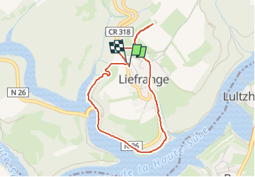
Liefrange

dridri002
User

Length
3.6 km

Max alt
448 m

Uphill gradient
127 m
Km-Effort
5.3 km

Min alt
324 m

Downhill gradient
128 m
Boucle
Yes
Creation date :
2024-10-17 13:57:16.169
Updated on :
2024-10-17 14:55:03.681
49m
Difficulty : Easy

FREE GPS app for hiking
 SityTrail
IGN / Geographical institutes
SityTrail Plus
The world is yours!
About
Trail Walking of 3.6 km to be discovered at Unknown, Canton Wiltz, Lac de la Haute-Sûre. This trail is proposed by dridri002.
Positioning
Country:
Luxembourg
Region :
Unknown
Department/Province :
Canton Wiltz
Municipality :
Lac de la Haute-Sûre
Location:
Unknown
Start:(Dec)
Start:(UTM)
706379 ; 5532703 (31U) N.
Comments